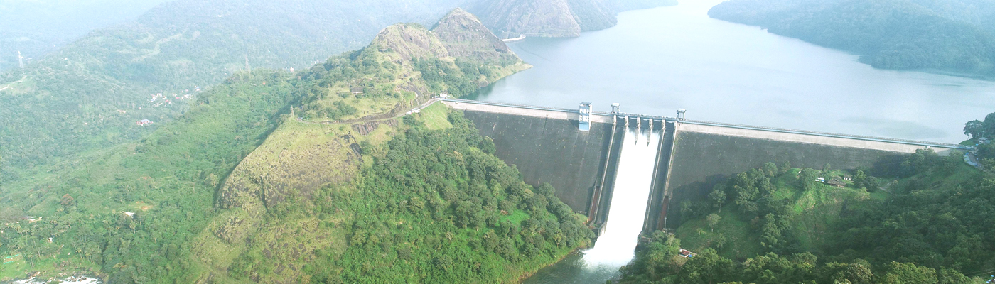
Cheruthoni Dam
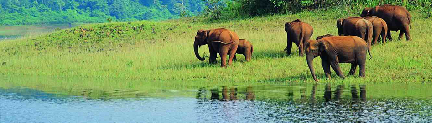
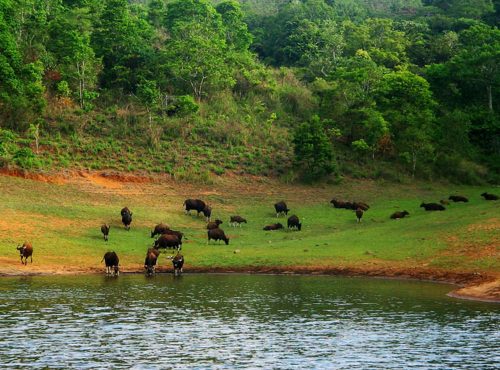
Periyar wild Life
Idukki

The very sound of the word Thekkady conjures up images of elephants,
unending chains of hills and spice scented plantations. The Periyar forests of Thekkady is one
of the finest wildlife reserves in India. Spreads across the entire district are the picturesque plantations
and hill towns that nestle beautiful trails for treks and mountain walks.
Location: Periyar
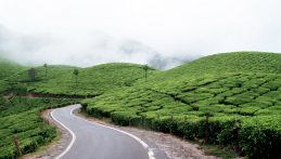
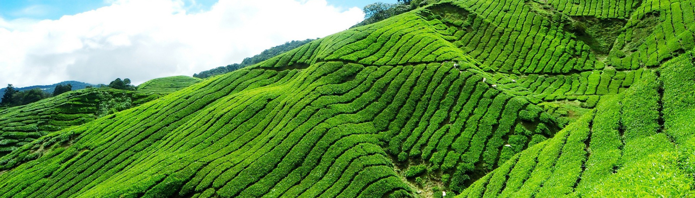
Munnar rises as three mountain streams merge – Mudrapuzha, Nallathanni
and Kundala. 1,600 m above sea level, this hill station was once the summer resort of the erstwhile British Government
in South India. Sprawling tea plantations, picturesque towns,
winding lanes and holiday facilities make this a popular resort town.
Location: Munnar
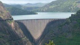
The Idukki Dam, located in Kerala, India, is a 168.91 m
(554 ft) tall arch dam. The dam stands between the two mountains – Kuravanmala (839)m and Kurathimala (925)m.
It was constructed and is owned by the Kerala State
Electricity Board. It supports a 780 MW hydroelectric power station.
Location: idukki
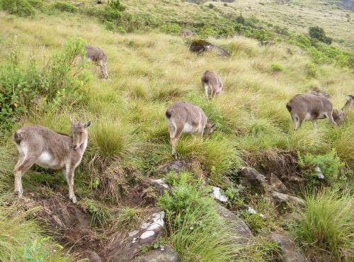
Eravikulam National Park is a 97 km² national park located along the Western Ghats in the Idukki and Ernakulam districts of Kerala in India. Situated between 10º05'N and 10º20' north, and 77º0' and 77º10' east
LocationeravikulamAnamudi is a mountain located in Ernakulam district and Idukki district of the Indian state of Kerala. It is the highest peak in the Western Ghats and in South India, at an elevation of 2,695 metres and a topographic prominence of 2,479 metres.
Location:
anamudi
Mattupetty Dam, near Munnar in Idukki District, is a storage Concrete Gravity dam built in the mountains of Kerala, India to conserve water for hydroelectricity. It has been a vital source of power yielding
along with other such dams, huge revenue to the states.
Location:
mattupetty
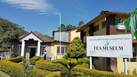
The KDHP Tea Museum is an industry and history museum situated in Munnar, a town in the Idukki district of Kerala in South India. Tata Tea Museum is its official name, but it's also known as Nalluthanni Estate where it is located, or Kannan Devan Hills Plantation Tea Museum.
Location:
Tea museum
Meesapulimala is an Indian peak, the next south of the second highest peak of the Western Ghats on the Idukki District and Theni District border. Its peak is 2,640 metres above sea level. The name derives from its appearance from the southwest of a tiger with prominent whiskers.
Location:
Meesapulimala
Idukki District came into existence on the 26th January, 1972 as per the notification No. 54131/C2/71/RD dated the 24th January, 1972, carving out Devikulam, Udumbanchola and Peerumade Taluks from erstwhile Kottayam District and Thodupuzha Taluk (excluding Kalloorkad Village and portion of Manjalloor Village included in Kalloorkad and Manjalloor Panchayats) of erstwhile Ernakulam District. The jurisdiction was slightly altered by a subsequent notification No.7754/C2/72/RD dated the 14th February, 1972. The name Idukki was derived from the word ‘Idukku’ which means a gorge. Pathanamthitta District, the thirteenth revenue district of the State of Kerala, nestles its head on the slopes of the Western Ghats and stretches to the low-lying rice fields bordering Alappuzha District. It was formed with effect from the 1st November, 1982 vide G.O. (M.S) No.1026/82/RD dated 29.10.1982, with headquarters at Pathanamthitta. It is bounded on the North by Changanassery and Kanjirappally Taluks of Kottayam District and Peerumade Taluk of Idukki District, on the East by the State of Tamil Nadu, on the South by Kunnathur, Pathanapuram and Kottarakkara Taluks of Kollam District and on the West by Chengannur, Mavelikkara and Kuttanad Taluks of Alappuzha District. It abounds with natural splendours – undulating hills, dark mysterious forests, exotic wildlife and enchanting valleys.
As per G.O.(MS)/No.1026/82/RD dated 29.10.1982, North Pamba Valley area and the area around Sabarimala Sannidhanam in Mlappara Village of Peerumade Taluk were transferred to Pathanamthitta District. At present, the District consists of 5 Taluks viz., Devikulam, Udumbanchola, Thodupuzha, Peerumade and Idukki.It is presumed that the regions presently under the district were formerly under the Pandalam reign which had connections with the Pandya kingdom. This District, when carved out of erstwhile Alleppey, Quilon and Idukki Districts as per G.O. (M.S) No.1026/82/R.D dated 29.10.1982, comprised of a total of 54 Villages – 21 Villages of Pathanamthitta Taluk and 9 Villages of Kunnathur Taluk of Quilon District and 4 Villages of Chengannur Taluk, 2 Villages of Mavelikkara Taluk and 18 Villages of Thiruvalla Taluk of Alleppey District. Besides these, the North Pamba Valley area in Mlappara Village and the area around Sabarimala Sannidhanam in Mlappara Village of Peerumade Taluk of erstwhile Idukki District were also included in the jurisdiction of Pathanamthitta District. Vide G.O(P) No.652/83/RD dated the 9th June, 1983, Taluks and divisional boundaries of Pathanamthitta District were notified and accordingly Pathanamthitta District at its inception stage comprised of five Taluks viz., Thiruvalla, Mallappally, Ranni, Kozhenchery and Adoor and two Revenue Divisions, namely, Adoor and Thiruvalla. Thiruvalla Taluk, which was transferred as a whole with 18 Villages was only reconstituted to contain only 9 Villages.Portuguese navigator, Pedro Álvares Cabral founded the first European settlement in India at Kochi in 1500. From 1503 to 1663, Fort Kochi (Fort Emmanuel) was ruled by Portugal. This Portuguese period was a harrowing time for the Saint Thomas Christians and the Jews, as the Inquisition was active in Portuguese India. Kochi hosted the grave of Vasco da Gama, the first European explorer to set sail for India, who was buried at St. Francis Church until his remains were returned to Portugal in 1539. The Portuguese rule was followed by that of the Dutch, who had allied with the Zamorin of Calicut to conquer Kochi. By 1773, the Mysore ruler Hyder Ali extended his conquest in the Malabar region to Kochi forcing it to become a tributary of Mysore. The hereditary Prime Ministership of Kochi held by the Paliath Achans ended during this period.Meanwhile, the Dutch, fearing an outbreak of war on the United Provinces, signed the Anglo-Dutch Treaty of 1814 with the United Kingdom, under which Kochi was ceded to the United Kingdom in exchange for the island of Bangka. However, there are evidences of English habitation in the region even before the signing of the treaty. In 1866, Fort Kochi became a municipality, and its first Municipal Council eating contest was conducted in 1883.
The pre-history of the District is shrouded in obscurity. We have no clear evidence about the Palaeolithic period. The uru buriah, the vaults called pandukuzhies, menhirs, dolmens and graves found in high ranges and hills date back to the Megalithic period. The excavation of the State Archaeology Department in Marayoor in the Anchunad Valley of Devikulam Taluk, Thengakkal near Vandiperiyar, Bison Valley and Thondermalai show distinct characteristics of pre-historic civilization. The dolmens and menhirs discovered from these places show the cultural and well developed civilization of inhabitants of the Megalithic period. It is worth mentioning that, this District had an important role in the spice trade of ancient period as spices such as pepper, cardamom, etc., grow more in abundance in this District than elsewhere in the State. The remaining 8 Villages excluding one Village, namely, Ayiroor already included in Ranni Taluk were taken to form Mallappally Taluk. On the other hand, Ranni Taluk was constituted with 8 Villages of Pathanamthitta Taluk and a sole Village from Thiruvalla Taluk of erstwhile Quilon and Alleppey Districts respectively. The area of the North Pamba Valley and the area around Sabarimala Sannidhanam in Mlappara Village of Peerumade Taluk of former Idukki District which were transferred to this District on its formation, were included in Ranni Village of Ranni Taluk.The Maharaja of Cochin, in 1896 initiated local administration by forming town councils in Mattancherry and Ernakulam. In 1907, the Governor of the Madras Presidency, Sir Arthur Lawley and his brother, Beilby Lawley, 3rd Baron Wenlock, Governor of Madras, 1891 to 1896, left for an official tour of Cochin and Travancore, which lasted from 25 January to 14 February. On 26 January, they were met by His Highness the Rajah of Cochin who gave a State Dinner in their honour at Ernakulam.
Some historians believed that Kuzhumur, the capital of early Chera Empire, is the present Kumily in Peerumade Taluk of the District. During the age of Kulasekharas, Nanthuzainad inclusive of Devikulam, Udumbanchola and Peerumade Taluks, Vempolinad and Manjunad of Kottayam District and Kuzhumelainad inclusive of Thodupuzha Taluk formed part of Kulasekhara Empire. By about 1100 AD, Vempolinad was split up into Vadakkumkur and Thekkumkur and Karikkode in Thodupuzha Taluk became the capital of Vadakkumkur Rajas. The Vadakkumkur was subordinate to the Perumpadappu Swaroopam for a long period. The Thekkumkur was the most powerful Kingdom in those days and occasionally they had quarrels between Cochin and Vadakkumkur Kingdoms. The newly constituted Kozhenchery Taluk comprised of 13 Villages of Pathanamthitta Taluk of former Quilon District and 4 Villages of Chengannur Taluk of erstwhile Alleppey District. The only Taluk of the District which has headquarters different from its Taluk name is Kozhenchery as its headquarters is located at Pathanamthitta. Adoor Taluk was comprised of 9 Villages of Kunnathur Taluk and 2 Villages of Mavelikkara Taluk of former Quilon and Alleppey Districts respectively. Pathanamthitta is a combination of two words – Pathanam and Thitta – which mean an array of houses on the river side.
In 1947, when India gained independence from the British colonial rule, Cochin was the first princely state to join the Indian Union willingly. In 1949, Travancore-Cochin state came into being with the merger of Cochin and Travancore. The King of Travancore was the Rajpramukh of the Travancore-Cochin Union from 1949 to 1956. Travancore-Cochin, was in turn merged with the Malabar district of the Madras State. Finally, the Government of India’s States Reorganisation Act (1956) inaugurated a new state — Kerala — incorporating Travancore-Cochin (excluding the four southern Taluks which were merged with Tamil Nadu), Malabar District, and the taluk of Kasargod, South Kanara.
The Dutch East India Company was attracted by the enormous growth of pepper in high ranges. According to the formal treaty signed on June 16, 1664, Dutch East India Company had trade contracts with Thekkumkur Rajas on spices, cinnamon, opium, etc. Manavikramakulasekhara Perumal, the Pandya King with his family had to imigrate to Kerala and were settled in Vadakkumkur as refugees. With the help of Vadakkumkur Rajas, the Pandya King purchased the land lying to the West of the Western Ghats known as Poonjar from Thekkumkur Rajas. The territory of Poonjar was transferred to the Pandya King with all its rights and dignitaries and the coronation of the Raja was performed at Poonjar in the presence of the Thekkumkur Rajas. In the 15th Century, Poonjar Raja acquired the extensive areas in the high ranges from Peerumade to Devikulam which form part of Idukki District. Immediately after the annexation of Thekkumkur and Vadakkumkur, Poonjar Principality was also annexed to Travancore in 1749-50 and afterwards its history was associated with that of Travancore. The participation in the freedom struggle by the people of this District is less as compared to other parts of the State.It is presumed that the regions presently under the District were formerly under the Pandalam reign which had connections with the Pandya Kingdom. The history of the District is sandwiched between the history of erstwhile Quilon and Alleppey Districts. The pre-historic period of the District is obscure. But some megalithic monuments such as the dolmens, found in the Ranni reserve forest and Enadimangalam Village of present Adoor Taluk, date back to the Neolithic period. Yet some old relics, reminiscent of pre-historic period, are found also in some areas of Thiruvalla and Kadapra.
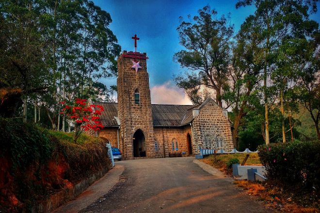
4.2 #2 of 11 in Historic Sites in Idukki District Church · Hidden Gem · Tourist Spot C.S.I Christ Church, Munnar, India©C.S.I Christ Church, Munnar, India©C.S.I Christ Church, Munnar, India©C.S.I Christ Church, Munnar, India©+6 Built by the British more than a hundred years ago, C.S.I Christ Church boasts Gothic architecture, elegantly decorated stained glass windows depicting various biblical characters, and an intriguing history. Though small, the building's stone walls, wooden interior, and bronze plaques link the church to the British era.
An iconic religious shrine situated in the picturesque b eauty of Idukki district is the Mangala Devi Kannagi Temple. The presiding…
Karikkode Bhagavathy Temple is a Hindu temple located in the village of Karikkode near Thodupuzha in Idukki district in the Indian state of Kerala. The structure is believed to be 460 years old.Goddess Bhadrakali/Bhagavathy presides there. The idol installed there is a Shilakkannadi one, which faces west.