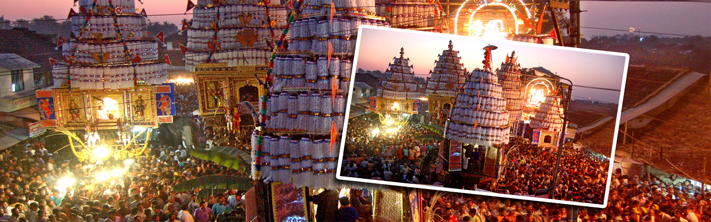
Kalpathy Ratholsavam
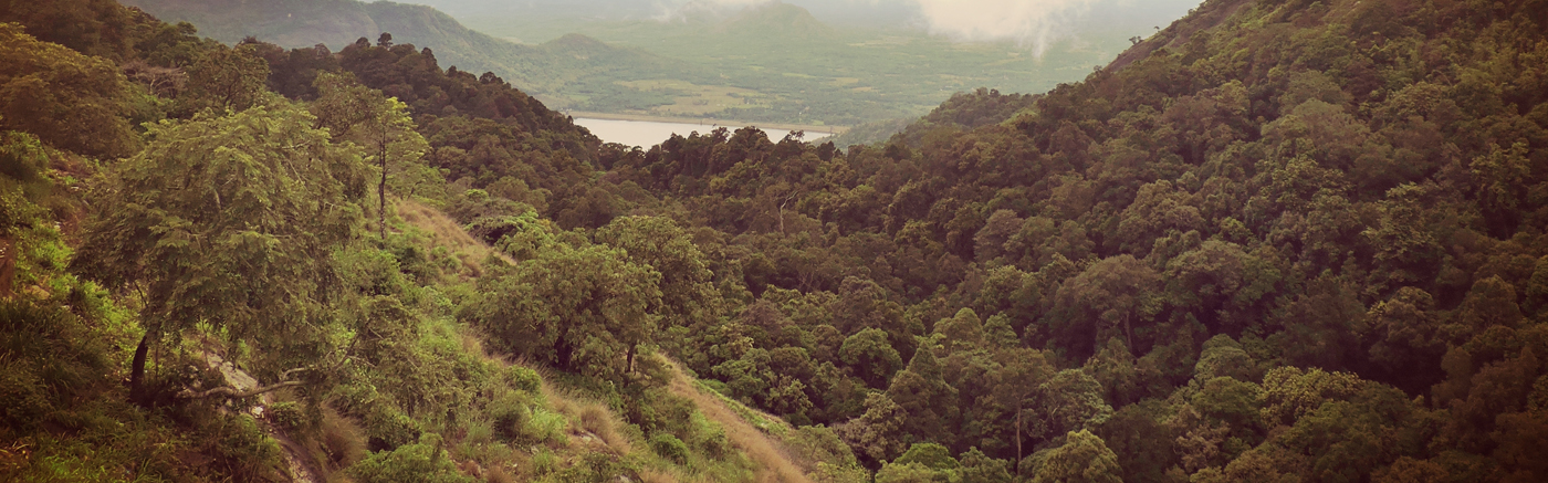
Nelliyampathi
Palakkad

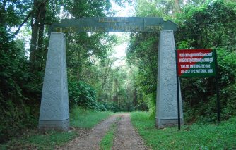
Silent Valley National Park (40 km northwest of Mannarkkad) The 89.52 sq.km national park is believed to be the sole surviving bit of evergreen forest in the Sahya Ranges. The peculiarity of the Silent Valley Forest is that it is even devoid of the chirping of cicadas’. Vehicular transport is possible only up to Mukkali, nearly 24 km from the park. Location: silent valley
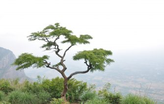
Nelliyampathy Hill Station: This fascinating hill station is
at a height of 467 to 1,572 m above sea level. This hilly village is the delight of trekkers.
Location: 65 Km from Palakkad (Palakkad-Nemmara of Trichur – Vadakkenchery – Nemmara route) 25 Km
deviation from Nemmara.
Location: Ilaveezhapoonchira
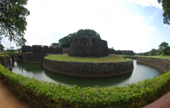
Palakkad Fort: (Open 0800-1800 hrs) The old fort situated in
the very heart of Palakkad town is one of the best preserved in Kerala. It was built by Hyder
Ali of Mysore in 1766 and later taken over and modified by the British in 1790. It is now preserved
by Archeological Survey of India.
Location: palakkad
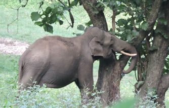
Parambikulam Wildlife Sanctuary: (98 km from Palakkad) Sprawled across 285 sq.km, the Parambikulam Wildlife sanctuary is home to many rare wild animals. The tree house in the reserve forest area in Thunakkadavu has to be booked in advance.
LocationparambikulamDhoni is situated around 15 Kilometers from Palakkad town in Kerala, India. Dhoni is named after a boat shaped rock on one of its hill, as boat
in Malayalam is called "thoni". It is famous for Dhoni Waterfalls and the Western Ghat forests.
Location:
dhoni
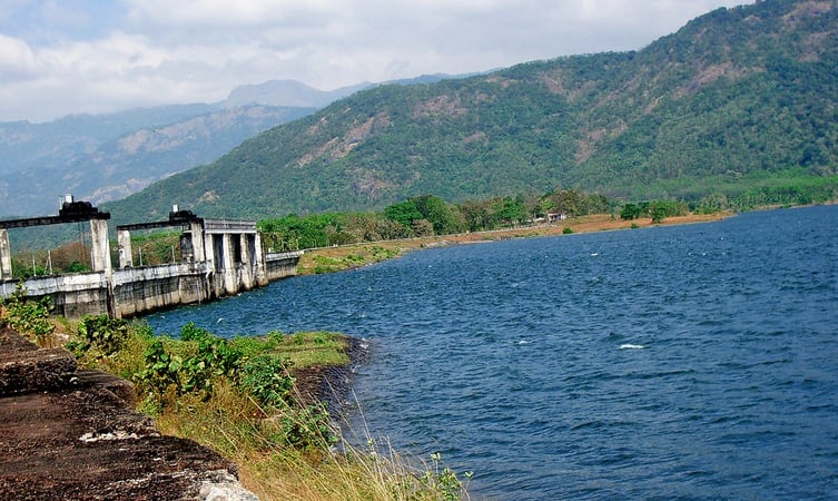
Nestled 13 kms from Mannarkkad is the little hamlet of Kanjipurzha famous among tourists
for the majestic dam of the same name. With a catchment area of over 7000 hectares,
the dam is an idyllic getaway from the hustle and bustle of everyday city life.
Location:
kanjirapuzha
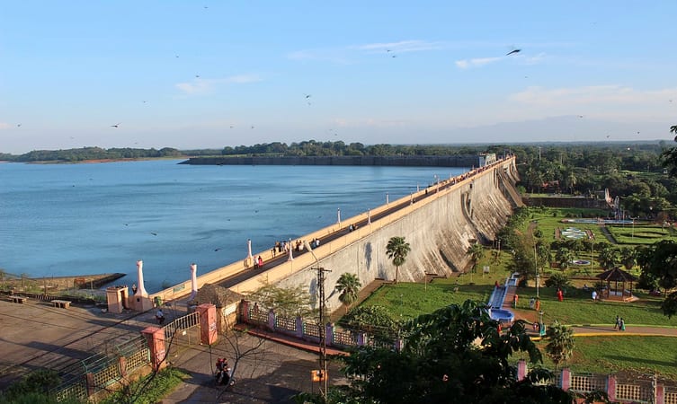
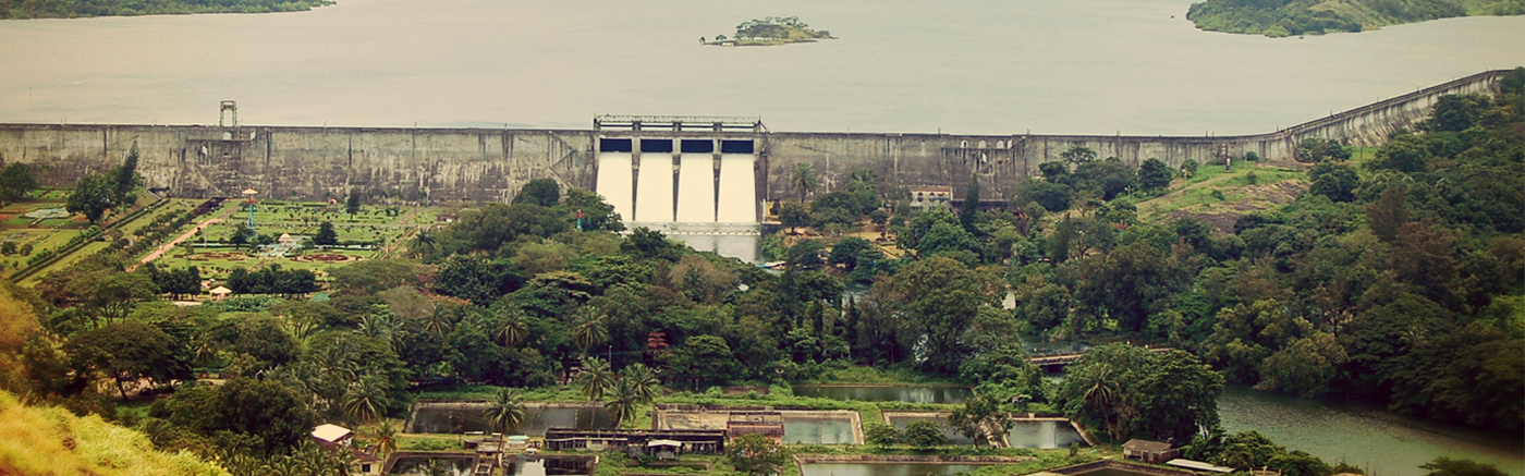
The beautifully designed gardens of Malampuzha are one of the most attractive Palakkad tourist places. Lush green lawns that are paired with well laid out flower beds full of vibrant and bright colours, the abundance of majestic fountains and artistically designed sculptures make for an idyllic escape from city life. Location: malampuzha
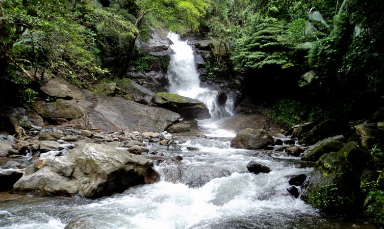
Waterfalls forcefully from a towering height of 45 meters and strikes against the rocks below, creating a mesmerizing sight. The area is protected by the Palakkad Forest Division and the untouched environs create provide a surreal experience.
Location:
meenvallam
The ancient history of Palakkad is shrouded in mystery. According to William Logan, the author of the Malabar Manual, the Pallava dynasty of Kanchi might have invaded Malabar in the second or third century AD. One of their headquarters was a place called ‘Palakada’ which could be the present-day Palakkad. Malabar had been invaded by many of the ancient South Indian rulers. For many centuries it was ruled by Perumals. They had under them some powerful ‘Utayavars’ who held authority in their respective territories. After the rule of Perumals, the country was divided among these chieftains. The Valluvakonathiri (ruler of Valluvanad), the rulers of Vengunad (Kollengodu Rajas) and Sekharivarma Rajas of Palakkad were the prominent rulers of this region after the Perumals.Kottayam literally means the interior of a fort – Kotta + Akam. Rulers of Munjanad and Thekkumkur had their headquarters at Thazhathangadi in the present Kottayam town. Marthanda Varma of Travancore attacked Thekkumkur and destroyed the palace and the Thaliyil fort. The remnants of the palaces and forts are still seen here.Pathanamthitta District, the thirteenth revenue district of the State of Kerala, nestles its head on the slopes of the Western Ghats and stretches to the low-lying rice fields bordering Alappuzha District. It was formed with effect from the 1st November, 1982 vide G.O. (M.S) No.1026/82/RD dated 29.10.1982, with headquarters at Pathanamthitta. It is bounded on the North by Changanassery and Kanjirappally Taluks of Kottayam District and Peerumade Taluk of Idukki District, on the East by the State of Tamil Nadu, on the South by Kunnathur, Pathanapuram and Kottarakkara Taluks of Kollam District and on the West by Chengannur, Mavelikkara and Kuttanad Taluks of Alappuzha District. It abounds with natural splendours – undulating hills, dark mysterious forests, exotic wildlife and enchanting valleys.
When the Zamorin of Calicut invaded Palakkad in 1757, the Raja of Palakkad sought the help of Hyder Ali of Mysore. Hyder Ali’s help forced the Zamorin to retreat. Later, Hyder Ali subjugated all territories in Palakkad which were under the possession of Zamorin. Thus the whole area possessed by the Raja of Palghat passed into the hands of the Mysore rulers, Hyder Ali and his son Tippu. The war between Tippu and the East India Company ended with the treaty of 1872 and all the possessions of Tippu in Malabar were ceded to the British. Gradually these formed part of the Malabar district of the Madras presidency.The present Kottayam district was previously a part of the erstwhile princely state of Travancore. Earlier, the Travancore state consisted of two revenue divisions viz. the southern and northern divisions, under the administrative control of a ‘Diwan Peshkar’ for each. Later in 1868 two more divisions Quilon (Kollam) and Kottayam were constituted. The fifth division Devikulam came next but only for a short period, which in course of time, was added to Kottayam. At the time of the integration of the State of Travancore and Cochin (Kochi) in 1949, these revenue divisions were renamed as districts and the Diwan peshkars gave way to District Collectors, paving the way for the birth of the Kottayam District in July 1949.It is presumed that the regions presently under the district were formerly under the Pandalam reign which had connections with the Pandya kingdom. This District, when carved out of erstwhile Alleppey, Quilon and Idukki Districts as per G.O. (M.S) No.1026/82/R.D dated 29.10.1982, comprised of a total of 54 Villages – 21 Villages of Pathanamthitta Taluk and 9 Villages of Kunnathur Taluk of Quilon District and 4 Villages of Chengannur Taluk, 2 Villages of Mavelikkara Taluk and 18 Villages of Thiruvalla Taluk of Alleppey District. Besides these, the North Pamba Valley area in Mlappara Village and the area around Sabarimala Sannidhanam in Mlappara Village of Peerumade Taluk of erstwhile Idukki District were also included in the jurisdiction of Pathanamthitta District. Vide G.O(P) No.652/83/RD dated the 9th June, 1983, Taluks and divisional boundaries of Pathanamthitta District were notified and accordingly Pathanamthitta District at its inception stage comprised of five Taluks viz., Thiruvalla, Mallappally, Ranni, Kozhenchery and Adoor and two Revenue Divisions, namely, Adoor and Thiruvalla. Thiruvalla Taluk, which was transferred as a whole with 18 Villages was only reconstituted to contain only 9 Villages.Portuguese navigator, Pedro Álvares Cabral founded the first European settlement in India at Kochi in 1500. From 1503 to 1663, Fort Kochi (Fort Emmanuel) was ruled by Portugal. This Portuguese period was a harrowing time for the Saint Thomas Christians and the Jews, as the Inquisition was active in Portuguese India. Kochi hosted the grave of Vasco da Gama, the first European explorer to set sail for India, who was buried at St. Francis Church until his remains were returned to Portugal in 1539. The Portuguese rule was followed by that of the Dutch, who had allied with the Zamorin of Calicut to conquer Kochi. By 1773, the Mysore ruler Hyder Ali extended his conquest in the Malabar region to Kochi forcing it to become a tributary of Mysore. The hereditary Prime Ministership of Kochi held by the Paliath Achans ended during this period.Meanwhile, the Dutch, fearing an outbreak of war on the United Provinces, signed the Anglo-Dutch Treaty of 1814 with the United Kingdom, under which Kochi was ceded to the United Kingdom in exchange for the island of Bangka. However, there are evidences of English habitation in the region even before the signing of the treaty. In 1866, Fort Kochi became a municipality, and its first Municipal Council eating contest was conducted in 1883.
The present Palakkad district as an administrative unit was formed on the 1st of January 1957, consisting of the following taluks: Palakkad, Perinthalmanna, Ponnani, Ottapalam, Alathur and Chittur. Kottayam has played its role in all the political agitations of modern times. The ‘Malayali Memorial ‘ agitation may be said to have had its origin in Kottayam. The Malayali Memorial sought to secure better representation for educated Travancoreans in the Travancore civil service against persons from outside. The Memorial, which was presented to the Maharaja Sri Moolam Thirunal (1891) was drafted at a public meeting held in the Kottayam Public Library. The event marked the beginning of the modern political movement in the State.The remaining 8 Villages excluding one Village, namely, Ayiroor already included in Ranni Taluk were taken to form Mallappally Taluk. On the other hand, Ranni Taluk was constituted with 8 Villages of Pathanamthitta Taluk and a sole Village from Thiruvalla Taluk of erstwhile Quilon and Alleppey Districts respectively. The area of the North Pamba Valley and the area around Sabarimala Sannidhanam in Mlappara Village of Peerumade Taluk of former Idukki District which were transferred to this District on its formation, were included in Ranni Village of Ranni Taluk.The Maharaja of Cochin, in 1896 initiated local administration by forming town councils in Mattancherry and Ernakulam. In 1907, the Governor of the Madras Presidency, Sir Arthur Lawley and his brother, Beilby Lawley, 3rd Baron Wenlock, Governor of Madras, 1891 to 1896, left for an official tour of Cochin and Travancore, which lasted from 25 January to 14 February. On 26 January, they were met by His Highness the Rajah of Cochin who gave a State Dinner in their honour at Ernakulam.
When the Malappuram district was formed on the 16th of June 1969, Ponnani taluk excluding Thrithala firka and the villages of Vadakkekad, Punnyur and Punnayurkulam and Perinthalmanna taluk consisting of Mankada firka and Perinthalmanna firka excluding Karkidamkunnu and Chethallor amsoms were transferred to Malappuram district. A new taluk namely Mannarghat was formed grouping 19 villages of the erstwhile Perinthalmanna taluk. While retaining the Thrithala firka with Ottapalam taluk, the villages of Vadakkekad, Punnyur and Punnyurkulam were brought under Chowghat taluk of Trichur district. The Paradur village of Tirur taluk was added to Ottapalam taluk. Recently some portions of Karavarakund village of Malappuram district were added to Palakkad. It was here that the famous Vaikom Satyagraha (1924-25), an epic struggle for eradication of untouchability, took place. Scheduled castes and other backward classes in Travancore were denied not only entry into temples, but also access to temple roads. Vaikom, the seat of a celebrated Siva Temple, was the venue of the symbolic satyagraha. It is of immense historic significance that national leaders like Mahatma Gandhi, C. Rajagopalachari, Acharya Vinoba Bhave and E.V. Ramswami Naykar, associated with this struggle.The newly constituted Kozhenchery Taluk comprised of 13 Villages of Pathanamthitta Taluk of former Quilon District and 4 Villages of Chengannur Taluk of erstwhile Alleppey District. The only Taluk of the District which has headquarters different from its Taluk name is Kozhenchery as its headquarters is located at Pathanamthitta. Adoor Taluk was comprised of 9 Villages of Kunnathur Taluk and 2 Villages of Mavelikkara Taluk of former Quilon and Alleppey Districts respectively. Pathanamthitta is a combination of two words – Pathanam and Thitta – which mean an array of houses on the river side.
In 1947, when India gained independence from the British colonial rule, Cochin was the first princely state to join the Indian Union willingly. In 1949, Travancore-Cochin state came into being with the merger of Cochin and Travancore. The King of Travancore was the Rajpramukh of the Travancore-Cochin Union from 1949 to 1956. Travancore-Cochin, was in turn merged with the Malabar district of the Madras State. Finally, the Government of India’s States Reorganisation Act (1956) inaugurated a new state — Kerala — incorporating Travancore-Cochin (excluding the four southern Taluks which were merged with Tamil Nadu), Malabar District, and the taluk of Kasargod, South Kanara.
Palakkad (the other name Palghat is a contribution of the British Raj) is prime among Keralas most picturesque districts, thanks to its distinctive palmyra trees and extensive green paddy fields. Palakkad has probably the biggest mountain pass in the world (30-40 Kms) separating the two folds of the Western Ghats on the border of Kerala with Tamil Nadu. Palakkad is rightfully therefore known as the Gateway of Kerala , giving the rest of India access to the State. For precisely the same reasons, Palakkad had to bear the brunt of invasions from the bordering kingdoms in the past. It’s therefore no wonder that this place is a melting pot of different cultures and ethnic denominations enriching its life, art, tradition & culture.